Saturday, March 31, 2018

Where to hike with a dog in Lake County: Redbud Trail

Heading down to Baton Flat with Cache Creek in the distance.
This trail has everything: views of water, birds, and wildflowers for you to soak in while your dog enjoys miles of roaming space.
If you go in the winter you might see bald eagles, as Cache Creek is one of their favorite spots to fish, but right now might be the best time to go because the Redbud Trail is known for its wildflowers.

The parking lot for the trailhead is located right off eastbound Highway 20 about an hour from Ukiah. The services there are only pit toilets and garbage cans.
The trail heads first through a meadow toward the hills, then gradually winds upward through what can look like moonscape in the winter.
About a mile and a half up, you hit a trail junction and some glorious views of Cache Creek. To the right is the Perkins Creek Trail, which continues up and along the saddle for miles. To stay on the Redbud Trail and eventually reach the creek at Baton Flat, turn right. Whichever direction you choose, the views along this section of the trail are spectacular.
After another mile and a bunch of switchbacks that head down the mountain youll reach Baton Flat, where its a lot easier to hear the water than reach it.
When the flows are low enough to cross, you can continue on another three miles to Wilson Valley, but I didnt dare cross the creek when I went. It was nerve-wracking just watching the dog take a dip.

Pausing in Baton Flat with Cache Creek to the right.
Words to the wise:
• Based on the hoofprints I saw, you will likely share the trail with elk, and I did encounter some horseback riders. But save for only one other human, I had the trail to myself on a weekday.
• Unless you go very early in the day, this trail cant be fun in the summer as it must get blazing hot and there is no water available for humans.
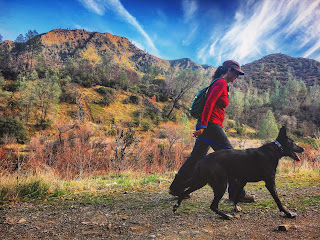
Sunday, February 25, 2018

Where to hike with a dog in Yolo County: Blue Ridge Trail to Fiske Peak


This is the second hike I’ve done in the Cache Creek Recreation Area and I can’t recommend either enough.
Near Cache Creek with Blue Ridge and Fiske Peak in the background. 
The first was the Redbud Trail in Lake County, which I understand is particularly gorgeous in the spring, and earlier this winter I hiked up to Fiske Peak on the Blue Ridge Trail in the Yolo County section of Cache Creek.
Neither trail would be much fun in summer, and certainly not the hike up to Fiske Peak, which even in mid-January had me wishing I had brought twice as much water, especially for the dog.
The trail begins close to the parking lot for the Lower Yolo County Park off Highway 16 in the Capay Valley. There are pit toilets to use before you hike down to the water and cross the creek using a cement bridge that is no longer open to vehicles. Up the hill to left begins the trail.
Photo credit for this and above: Nathan DeHart.
The first part through the trees is flat, then you being a gradual climb up a narrow trail barely carved into the hillside (shown to the left), then you move into the rocks and keep going up and up!
Up so steeply, in fact, that there are many sections of the trail that seem to disappear into the rocks, and during the rainy season those sections can’t be fun.
It is about eight miles if you hike to the top of Fiske Peak and back, but I only made it to the top of a smaller hill near the peak. The views were still extraordinary, though, as we saw a snow-covered mountain to the northeast that could have been Mount Shasta!

Words to the wise:
The views were amazing less than halfway up!
• I did not see any signs explaining the leash rules, but many sections of the trail are so narrow and curvy that it’s best to have your dog on leash unless they are very good at sharing the trail.
Two more good reasons to keep your dog on leash, except for maybe the sections when you need both hands free for rock climbing, are the ticks and horses. My dog’s head was covered in ticks after romping off the trail, and I was very glad she was on leash when we ran into some people on horseback at the bottom near the creek. Unless your dog is very well-behaved around horses, it’s probably best to keep them on leash in that section.
• This trail is VERY steep and tricky to navigate in parts, and my legs were definitely shaking on the way down.
• Again, bring LOTS of water!

Sunday, January 28, 2018

Where to hike with a dog in Calistoga: Oat Hill Mine

If you like hiking up mountains with your dog off-leash, this trail is a good choice.
Checking out the view along the Oat Hill Mine trail.
It also offers great views and an even better workout, so it is a very popular trail with hikers and bicyclists as well as dog owners. So if you'd rather not run into a lot of other people and dogs, it might not be the best choice for you.
The trailhead is located just off the intersection of Highway 29 and the Silverado Trail and has a small parking lot that fills up fast. 
The first mile heads up pretty gradually above the vineyards, then gets more rocky between miles 1 and 2. Between miles 2 and 3 (there are posts making each mile) it gets considerably more rocky, with certain parts very slippery in the rain. The rockier the trail the more impressive the views, however.
After mile three, the trail starts to get very narrow and there are a few precarious spots that are quite difficult to share with a passing bicyclist. Unless your dog is very good about conceding right-of-way, which mine has no concept of, it might be best to keep them on leash in those sections.

The view get better but the trail gets rockier as you head up.
Words to the Wise: There is no water available at the trailhead, so be sure and bring plenty of your own. Especially if you are hiking when its warm, which I definitely don't recommend, since there is very little shade. I've only hiked this trail in late December, which is probably one of the best times to go other than early spring.

Wednesday, December 20, 2017

Where to hike with a dog near Ukiah: Cow Mountain

If you and your dog are in good shape, a great place for you both to hike in the cooler months is the Valley View Trail on Cow Mountain.
Approaching the  "view" part of the Valley View Trail.
Most months of the year, this trail gets blazing hot and the small streams that pass alongside and over it have long since dried up. But in late fall and winter, the temperatures are cool enough to keep the trek more than bearable all day long, and there’s also plenty of water in the creeks for your dog to drink along the way.
You can allow your dog off-leash as long as they respond to voice commands, which is important because hunters and plenty of wildlife can be found on the mountain. Since she can walk off-leash, my dog loves hiking here so much that she whines as soon as she realizes that is where I’m driving. And she figures that out faster each time.

The Valley View Trail is reached by a short drive from Ukiah beginning east on Talmage Road, taking a right on Old River Road and then a left on Mill Creek Road. After passing the ponds, you will come to a trail sign on the left and parking on the right near a port-a-potty.

After the sign, the trail heads straight up the mountain with few breaks. You are rewarded with great views of the valley for your climb, however. And in the spring, the trail is bordered with wildflowers, especially Shooting Stars, Indian Warriors and Sticky Monkeys.
However, spring also brings the ticks, and a dog can easily come home with more than two dozen crawling on them; but the ticks seem to be far less plentiful when it is cold and dry.
About a mile up, the trail levels out a bit at a spot that gives you the best view of the valley and the second bench you will encounter. Once you start heading straight up again and have the mountains at your left, you will come to a third bench.

The beginning of the Mayacamas Trail.
If you stop there, you can keep the hike to about an hour. But if you have a couple more hours and plenty more energy to spare, you can continue on to the year-round waterfall on the Mayacamas Trail.
About 3.5 miles from the parking lot, after you’ve left the dense vegetation and the trail has flattened a bit, look for a trail that heads to the left and toward the water you can hear rushing below you.
There is no sign at the fork, but a short ways down you will hit the creek and finally a sign telling you that you’re on the Mayacamas Trail. If you head to the left, about a mile down you will reach the waterfall.

The waterfall and creek have water year-round, so they can provide refuge for you and your dog if you do attempt the trail on a hot day. If you hike to the waterfall during heavy flows, be prepared to cross the creek more than once and soak your shoes.


Long before you reach the waterfall, only about 30 minutes up, there is this gorgeous section:

Thursday, July 13, 2017

Where to hike with a dog in the Sierra Nevadas: the Lakes Basin


If you love hikes where your dog can be off-leash and it loves jumping into water, the Lakes Basin has a beautiful trail called the Bear Lakes Loop in the Plumas National Forest you will both adore.

Just one of the gorgeous lakes.
Located in the northern Sierra Nevadas about 2.5 hours northeast of Sacramento, the trail starts just a few miles south of Graeagle on the Gold Lake Highway.
We started our hike on the trailhead near the Gold Lake Lodge, but there are other trailheads further north that also lead to the loop.
The trail is mostly dirt with a few rocky sections, and about a two weeks ago had plenty of downed trees and full creeks. Most of the creeks were much easier for the dog than the humans to cross, but one had a high and sturdy bridge that she needed to be coaxed into using.
There isn’t a lot of shade, but luckily the altitude made it cool enough for the humans, as dogs can jump in all the lakes they want.
Plenty of snow still in early July.
And the lakes are what makes this hike worth so worth the journey. Some are large and some are quite small, but all are clear and beautiful and come so frequently at the end of the loop that you almost get bored with them. Almost.
But the journey we took to get there, the winding I-70, called the Feather River Highway, was beautiful in its own right.

Words to the wise:
• If you do drive I-70, on your way be sure and stop at Quincy, a cute town that reminded me of a smaller version of Ashland, Ore., featuring a great natural foods store with plenty of tasty snacks for the road.
• Also be sure and check both the road, trail and weather conditions, as the trail had barely opened by July due to the heavy snowfall in the mountains. And even then there were still sections of the trail that were covered in slick slopes of snow that were passable but a bit nerve-wracking – at least to the humans.

Veronica Lake.

Friday, June 30, 2017

Where to take a dog in Jackson Hole, WY: Snow King


If you and your dog love hiking hills you will love Jackson Hole, because it has one of my favorite mountain climbs right behind it.

About halfway up Snow King Mountain.
Just six blocks from its famous town square (where you can’t take your dog, by the way) is Snow King Resort, which is full of snow and skiers in the winter, but is great for hiking once the snow melts.
When I visited in early October, fresh snow made the steep trek treacherous in spots, but it quickly melted and most people I met were handling the slick ground just fine in shoes with good traction.
If your dog is social, this is also a good place to let them off leash, since we met many other people with dogs that were all off-leash.
I never quite made it to the summit, but the views of the valley and mountains, including the Grand Tetons, are spectacular even if you only make it halfway up.
This is a great spot to exercise both dogs and humans, and to watch both the sunrise and sunset.

Just one set of mountains you can see on the hike.

Monday, May 22, 2017

Where to hike with a dog in Aptos (Santa Cruz County): the Forest of Nisene Marks


Continuing on one of the trails meant crossing Aptos Creek.
Hiking with your dog often means trudging up a dusty fire road. 
So a great choice for anyone wishing for some trees and shade is a hike in the Forest of Nisene Marks, located about 20 miles south of Santa Cruz.
Funny thing is, I would have been perfectly happy to stay on the fire road in this park, since it takes you deep among the towering redwoods.
But this forest also welcomes your dog on some of its lower trails, which lead you away from any vehicles and alongside Aptos Creek, which travels wide and clear through much of the park.
Words to the wise: Construction in the Aptos Village shopping center makes the park entrance harder to find these days, but making it inside is well worth the effort.